Measure distance and area using map or GPS - share your results the easy way…
Use MapPad to calculate areas, perimeters and distances and save, export or share your measurements.
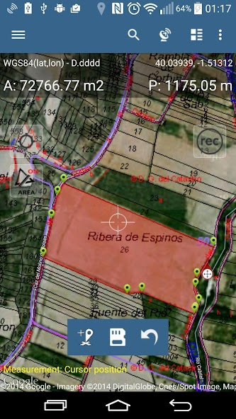
MapPad is providing multi-purpose mapping solution allowing location capture and determines distance and area for the shapes drawn on the map or captured using real-time GPS tracking.
Calculate area of the field or a walk distance instantly using Google or Bing Map Satellite view. Save petrol and time and capture features with few clicks on the map.
With MapPad you can capture, manage and share your data easily.
MapPad is a very useful tool for anyone involved in forestry, agriculture, engineering and real estate management.
Please visit our website to find out how to prepare offline map and get more information about this product.
Selected features:
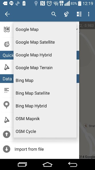
- Base maps: Google Maps, Open Street Map, Bing Maps
- Google Maps Overlays (Custom WMS or ArcGIS Server Tiled service), some layers like US Topographic map have been predefined.
- Very accurate measurement of areas and distances.
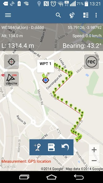
- 3 methods of measurement are supported (Tap on the map, GPS location, Map cursor location).
- Support for number of metric and imperial units.
- Support for several global and local coordinate systems, if you require support for any other spatial reference please get in touch.
- Possibility to capture waypoints and group them in categories.
- Possibility to add or edit title and description for each recorded measurement and waypoint.
- Export single or multiple measurements or waypoints to SHP File, Geojson, ArcGIS Json, KML, GPX, CSV and DXF to SD Card or cloud services las well as direct export to Open Street Map.
- Share single waypoint location directly by SMS, E-mail or other ways.
- Elevation profile available for measurements done by GPS.
- Import of KML and GPX files to the application.
- GPS status and satellites status.
- Address, location search.
- Quick open exported KML files in Google Earth
- Ability to set default measurement units, waypoints' categories colours, track recording time and distance interval, transparency of Google Maps overlays and much more...
Our users are successfully using MapPad in number of projects and applications.
Get free Primogems, Mora, Experience, and more with these November 2024 Genshin Impact codes, 5.1 livestream codes, and find out how to redeem active codes.
If you are bored with playing the vanilla version of Metaphor ReFantazio, you can check out these five mods.
Struggling with your submissions for Roblox's The Haunt event in 2024? Check out our guide on using Dress to Impress to create your captures!
Our walkthrough for Dragon Age: The Veilguard with some handy tips and tricks, with guides for puzzles, bosses, companions, equipment, romance, and more!
Which faction should you pick in Dragon Age: The Veilguard?
Looking for some bonus resources in Sea of Conquest: Pirate War? We’ve got you covered with these codes for the latest seafaring freebies.
On our website, you can easily download the latest version of MapPad! No registration and SMS required!